Introduction
This document covers a very important and ecologically vital geographical area which is rich in biodiversity - the Mahadayi/Mandovi River Valley in the central Western Ghats. Most of the forests in the Western Ghats have already disappeared due to population pressure and ‘development’ schemes that do not consider the long term consequences but merely look at the short term gains. And now it is the turn of this pristine valley to fall under the axe.
 River Madei at Sonal Village, Sattari, Goa - Pic by Mohan Pai
This is mainly a pictorial documentation which attempts to bring out the natural wealth of this valley - its streams and waterfalls, its forests and wildlife, its people and the millennia old civilization and settlements on the banks of the river Mandovi in Goa all of which stand to be decimated due to Karnataka’s river valley project which proposes to divert a sizeable quantum of water from the Mahadayi to the Malaprabha river in Belgaum district of Karnataka. But the project is far more ambitious. It includes building as many as 11 dams on the Mahadayi and its tributaries in a small area of 50 sq km along with hydroelectric projects.
The project will submerge a vast area of thousands of acres; most of it will be thick forested area. The tribals living in the area will be displaced. Once these forests are destroyed there will be a drastic change in the ecology of the valley ruining its forests, wildlife and all its natural wealth.
 Gavali Tribals of Chapoli - Mother & Child - Pic by Srihari Kugaji
The core catchment area of the Mahadayi lies in the heavy rainfall, thickly forested, approximately 200 sq km of mountain topography of Khanapur taluka, barely 10 km upstream of Valpoi in Goa, where Karnataka’s diversion and hydroelectric dams are to come up.
In my earlier book “The Western Ghats” , I had attempted to bring out the ecological damage that is being continually inflicted on the Sahyadris. The biggest ecological damage inflicted upon the Western Ghats is deforestation. The Western Ghats eco-region with an area of about 1,59,000 sq. km has been classified as a global ‘Hotspot’. This means that this is an area which is rich in endemic plant species and which has already lost more than 70% of its original habitat and is under severe threat due to human pressure.
The Mahadayi is a comparatively minor stream that arises in the Western Ghats and the river valley is a large pocket of dense, pristine monsoon forests, one of the richest reservoirs of biodiversity in the world that reflects complexity in plant, animal, bird life and is home to some rare endangered species of bats.
Mahadayi river valley is in the news because of the inter-state water sharing dispute between Karnataka and Goa. The Mahadayi Valley has been facing many threats. Illegal felling of trees and illegal mining has been going on for decades. Large scale plantation of exotic species (acasia & mangium) has also been damaging the ecology of the area.
With water diversion and hydroelectric projects, the Mandovi river, Goa’s life-line, faces imminent threat of choking because of the reduction in water flow, siltation and disruption of its ecology due to change in its profile - perhaps being even reduced to a trickle in the summer months and possibility of seismic disturbances.
The main threat that is now looming over the valley is the Karnataka Government’s plans to divert a large quantum of water from the Mahadayi river and its tributaries to the Malaprabha river basin to help the acute water scarcity faced by the region in the Malaprabha basin. But as long as the exploitation of water resources continues in the Malaprabha region, no matter how much water and from where it is diverted, the Malaprabha valley is likely to face the same situation in the near future.
But the project is far more ambitious. It includes building as many as 11 dams on the Mahadayi and its tributaries in this small area along with hydroelectric projects. The project appears to aim at impounding a large portion of waters from the Mahadayi and its tributaries that flows into Goa, which will mean that Karnataka retains and controls all the dams and the Mahadayi waters.
It is estimated that this project will submerge a vast area amounting to about 3,000 hectares; most of it will be the thick forested area on Karnataka side of the valley. Once these forest are destroyed there will be a drastic change in the ecology of the valley reducing the rainfall, ruining its forests, wildlife, and all its natural wealth.
 Fungal diversity - Pic by Srihari Kugaji
The core catchment area of the Mahadayi lies in the heavy rainfall (3800mm-5700 mm per annum) thickly forested, approximately 200 sq. km of mountain topography of Khanapur taluka barely 10 km. upstream of Valpoi in Goa. A very large quantity of water that flows down the Mandovi all the year round originates in the streams and rivulets around Kankumbi, Jamboti, Talewadi, Gavali and Hemadga villages where Karnataka’s diversion and hydroelectric dams are to come up. The Mandovi river, Goa’s lifeline, faces imminent threat of choking because of the reduction in water flow, siltation and disruption of its ecology due to change in its profile - perhaps being even reduced to a trickle in the summer months.
Every variation in the Mahadayi water level will be crucial for Goa’s ecology, forests, wildlife, agriculture, drinking water, fishing and transportation.
Whither the Sahyadris ?
The Sahyadris or the Western Ghats is a major mountain range of the world that runs 1,600 km N-S forming the “girdle of the earth” and is the most important feature of the landscape of the southern peninsula of India. It has been classified as a “Global Biodiversity Hotspot” which is under constant threat due to human pressure.
It’s a precious gift of the Nature - priceless because the well-being of the entire southern peninsula hinges on the ecological stability of these mountains. And yet, there is a mindless exploitation and wanton destruction. The rate of forest destruction in the Sahyadris continues at a staggering rate. Tragically for the country and the region, most of the forest cover in the Western Ghats has disappeared.
The Western Ghats are remarkable headwaters and the main watershed for the southern peninsula serving six states; sustained by the heavy seasonal rainfall from the south-west monsoon, from which all the major and many smaller rivers of the southern peninsula originate and flow east or west emptying into the coastal waters. The real merit of the Western Ghats forests in terms of their watershed value is incalculable. These forests once destroyed are gone forever. No amount of scientific knowledge or investment in afforestation can get us back our rivers.
The Western Ghats eco-region covers an area of about 1,59,000 sq km and is shared by six states viz., Gujarat, Maharashtra, Goa, Karnataka, Tamil Nadu and Kerala. Around 40 districts fall within the limits of this region. Population density is lowest in the Dangs in Gujarat - 106/km2 and highest in Alapuzha in Kerala - 1489/km2. Tribal population classified as tribals (ST) are highest in Gujarat (14.9%), followed by Maharashtra (9.27%) and least in Tamil Nadu (1%) and Kerala (1.1%).
There are 58 protected areas - 13 National Parks and 45 Wildlife Sanctuaries. The total area of 14,140.36 km2 that is thus protected amounts to only 8.8% of the eco-region.
Of the remaining few pockets of dense pristine, evergreen forests, the Mahadayi River Valley located in the northern Karnataka and Goa now faces the Democles’s Sword in the shape of the proposed water diversion and hydroelectric schemes in Karnataka that will submerge an area of about 3,000 hactares, most of which will be the dense evergreen forests.
The Mahadyi River Valley one of the last “Wildernesses” with dense evergreen forests, abundant wildlife, beautiful streams and waterfalls covers an area of 750 sq km and is comparable to the Silent Valley(89.5 sq. km.) in Kerala in its wealth of biodiversity but much larger in area.
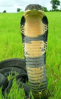 Pic by Amrut Singh
(The King Cobra - Ophiophagus hannah is the longest venomous snake in the world also called the Hamadryad which grows up to a length of 18 ft and is one of the most enigmatic creatures found in the Western Ghats. It is a snake that is highly feared and deeply respected and the Mahadayi Valley is a prime habitat of this snake. At Caranzol in Sattari taluka there are some well-identified habitats of the King Cobra.)
Global Biodiversity Hotspots
Norman Myers, a conservation biologist, in 1988 first identified ten tropical forest ‘hotspots’ characterised by exceptional levels of plant endemism and by serious levels of habitat loss. In 1990, Myers added another 8 spots to his list. Conservation International adopted Myer’s hotspots as its institutional blue print in 1989, and in1996.
To qualify as a hotspot, a region must meet two strict criteria: it must contain at least 1,500 species of vascular plants as endemic and it has to have lost at least 70% of its original habitat. These are the areas which are under constant threat due to human pressure. In the 1999 analysis, in all 25 hotspots were identified. A second major analysis was undertaken and the number or global hotspots stood at 34 in 2005.
Overall, the 34 hotspots once covered 15.7% of the Earth’s land surface. In all 86% of the hotspots’ habitat has already been destroyed. The intact remnants of the hotspots now cover only 2.3% of the Earth’s land surface. Over 50% of the world’s plant species and 42% of all terrestrial vertebrate species are endemic to these 34 biodiversity hotspots.
 Among the 34 Global hotspots of the world, two have been identified in India; the Eastern Himalayas and the Western Ghats .
Of India’s 15,000 plant species with 5,000 endemics (33%), 4050 plants with 1,600 endemic species are found in a 17,000 sq km strip of forests along the seaward side of the Western Ghats in Maharashtra, Goa, Karnataka and Kerala. The Western Ghats Eco-region has 938 vertebrates (36% endemic), 330 species of butterflies (11% endemic) and other lower plants and animals. Endemism is highest in amphibians (78%) and lowest in birds (4%). As per the classification of ‘hotspot’, the Western Ghats have lost more than 70% of its original habitat and forest cover. Many species have already become extinct or have become endangered and on the verge of extinction. Glassy Tiger (Parantica aglea Stoll) Wingspan: 70-85 mm - Pic by Mohan Pai
The Mahadayi river valley is rich in insects diversity and butterflies are perhaps the most colourful and conspicuous of insects. The butterflies in the valley include ‘Southern Birdwing’ , the largest of southern Indian butterflies with a wingspan of 140-190 mm and the smallest of the butterflies ‘Grass Jewel’ with a wingspan of 15-22 mm
Mahadayi - “the Great Mother Goddess”
Ancient carved image of ‘Gajalakshmi’ at Caranzol - Pic by Mohan Pai
In India, its mountains, rivers , trees and animals are honoured and revered more than any other nation in the world, seeing these objects as manifest divine creations. The rivers, especially are considered manifest forms of divine female powers that have descended from heaven. “Ganga Jal” is revered with implicit faith as an essential element of one’s salvation. “Ganga” in popular speech is used to describe any river since she is the Bhagirathi brought down to earth and could be received only by Lord Shiva and she is the mistress of all as in her they must all unite.
Quite a number of ancient stone sculptures, representing the River Goddess have been discovered in and around the banks of the Mahadayi river both in Khanapur, Karnataka and in Goa indicating the existence of a dominating cult of the River Goddess in the area.
The Boat Goddess sculptures depict the Goddess standing in a boat, holding a dagger in her right hand and a bowl in her left hand. She is known by various names such as ‘Naukayana’ Devi (Boat Goddess), ‘Ashtabhuja’ (eight hands) Durga, ‘Mahishasuramardini’, etc.
All these sculptures probably belong to Kadamba period (12th or 13th Century AD). These sculptures have been found mostly in Sattari taluka at Nadve, Savarde, Dhamashe, Shel-Melawalli, Dhada and Guleli. Mahadayi near Krishnapur - Pic by Srihari Kygaji
The Mahadayi river originates in Khanapur taluka of Belgaum district of Karnataka on the eastern slopes of the Sahyadris and flows west meeting the Arabian Sea near Panaji in Goa. But for the people of Khanapur and the eastern taluka of Sattari in Goa, She is the MAHADAYI - ”the Great Mother Goddess” as the name itself implies. The number of ancient carved images found scattered at Amgaon and Parvada in Khanapur Taluka and Sattari taluka of Goa at Caranzol, Savarde, Kodal, Rivem, Irvem, etc. represents the cult of the Mother Goddess worship on the banks of the Madei. The river Mahadayi becomes Madei in Sattari taluka of Goa and after the river Khandepar joins it at Bembol the river is called the Mandovi.
Like most monsoon-fed rivers, the Mahadayi also undergoes bewildering transformation during her seasons; slack, limpid pools of winter, partially dry beds of summer turning to fearsome torrents during the monsoons, submerging everything in its way and awesome in her destructive potential.
Damning the Rivers
When we dam the rivers, we literally damn them to an unnatural existence.
Patrick MacCully in his book “Silenced Rivers - The Ecology & Politics of Large Dams” says that the era of dams and damming rivers the world over is over (quite simply there are fewer and fewer rivers left to dam). In the United States now they are decommissioning dams and trying to restore their rivers to there original status, which is quite an uphill task. About 40 dams have been removed since 1999 when the breaching of Edwards Dam on Maine’s Kennebec river captured national attention. Another milestone was reached in October 2001, when conservationists celebrated the completion of a series of dam removals that restored 115 miles of the Wisconsin’s Baraboo river, the longest stretch of river ever returned to free flowing condition in America.
But in India state after state is hell-bent on damming the rivers either for irrigation or power orfor both under the guise of “development”. Past experience has proved that these so called“development” projects end up with far more incalculable, irreparable ecological damage. Thousands and thousands of sq. kilometers of forests have been submerged. In fact most ofthe forests in the Western Ghats have gone. The destruction of forests has very adverse effecton watersheds and catchment areas; thousands of families have been displaced, most of the time without proper resettlement; the wildlife and the flora of the area is completelywiped out; all this without any benefits to the local population. But what these projects in essence do is to destroy the ecology of the dammed rivers that have provided life-giving support for centuries to a wilderness of flora and fauna and civilisations on their banks. The ecology of the rivers is severely affected by dams, their waters running dry and they are reduced to a gutter status with only skeletal remains.
After these mega-investment, quite a number of dams get silted with not enough storage either for irrigation or to produce power. And there is also a danger of seismic disturbances to the areas.
 Anjunem Dam on Costi river, Goa. - Pic by Mohan Pai
Hydropower projects & greenhouse gas emission
Latest scientific estimates show that large dams in India ar responsible for about a fifth of India’s total global warming impact. The study titled, “Methane emission from Indian Large Dams” estimates the total generation of methane from India’s reservoirs could be around 45.8 million ton, more than the share of any other country in the world. These gases are produced by the rotting of the vegetation and soils flooded by reservoirs, and of the organic matter (plants, plankton, algae, etc. Large dams have been known to be emitters of greenhouse gases like methane, carbon dioxide and nitrous oxide for over a decade now.
Indian hydropower projects are already known for their serious social and environmental impact on the communities and the environment. The fact that these projects also emit global warming gases in such significant proportion should further destroy the myth.
The Water Disputes
The water endowed upper riparian States consider the water in their rivers as their property. As interstate rivers are not located entirely within a State but only flow through its territories, no State can lay exclusive use of such waters and/or deprive other States of their just share.
However, these States who zealously safeguard their autonomous status and rights forget or deliberately ignore their obligations to cooperate with each other while practising federalism. Because of this situation, many Chief Ministers of water deficit States have been forced to demand nationalisation of rivers.
The ongoing disputes are several- the Kaveri waters, the Krishna Basin, Indus Basin, Mahanadi Basin, the Indravati waters and now the Mahadayi waters. The Water disputes between the States are getting murkier due to the despicable actions of political opportunists. Vote bank politics has succeeded in dividing the culturally united dwellers of these basins into upper and lower riparian blocks to fight each other for their water rights. These people who are steeply bound by traditions for generations, who have been sharing the bounties of the river happily and its distress with concern for each other are now at each others throat fighting for their share of the same life-giving waters.
Karnataka’s unilateral decision to go ahead with the Mahadayi River Valley projects is now amounting to a very real threat. Karnataka is fully aware that the Mahadayi/Mandovi is a lifeline river for Goa and yet it is hell bent on diverting the Mahadayi waters into the Malaprabha basin. Most of the water from Karnataka’s Navilutirtha reservoir on Malaprabha goes for irrigation of water guzzling crops like sugarcane in its upper reaches creating a drought-like situation in its lower reaches. This has created a man-made water crisis in Hubli-Dharwad area. If Karnataka cuts a fraction of water released for irrigation, there will be no drinking water shortage for Hubli-Dharwad.
Goa State is a part of the narrow Konkan coastal strip on the western side of the Western Ghats (15 47’ 59’ and 14 53’ 47” North latitude and 74 20’13” and 73 40’33” East longitude. The entire eastern part of Goa State is flanked by the western slopes of the Sahyadris that extends in the form of an arc with a length of 125 km N/S and covers an area of about 750 sq km. The rainfall remains relatively high over this tract in view of the comparatively low elevation. The Sahyadri crestline zone borders Goa and Karnataka and most of the streams flowing into Goa, originate just across the border in Karnataka.

Vajra Sakhala Waterfalls in Chorla Ghat - Pic by Mohan Pai
The Mahadayi/Mandovi is the most important west flowing river of Goa. The river arises in the Western Ghats of Karnataka at Degaon in Khanapur taluka at an elevation of 940 m with a total length of 87 km(35 km in Karnataka and 52 km in Goa). The river and its tributaries drain about 2,032 sq km area out of which 375 sq km in Karnataka, 77 sq km in Maharashtra and 1,580 sq km in Goa. The Mahadayi/Mandovi river basin in Goa occupies 43% of the total area of the State and this explains why maintaining the ecology of the river is so vital to this small State.

Emerald-green fields on the banks of the Madei - a village near Honda, Sattari Taluka, Goa-Pic by Mohan Pai
The ecology of the Mahadayi basin is already very fragile on account of large scale deforestation and illegal mining in Khanapur taluka. Karnataka now proposes to intercept the yield from about 258 sq km which is the core catchment area of the Mahadayi. The massive diversion of the Mahadayi water from this area will see a quantum jump in the silt flowing down from the denuded mountain ranges from across the border and will result in water flow being reduced to a trickle. For Goa, the fresh water flows from the core catchment area that lies in the heavy rainfall, thickly forested area of about 200 sq. km. of mountain topography of Khanapur taluka barely 10 km upstream of Valpoi in Goa. A very large quantity of water that flows down the Mandovi all the year round originates in the streams and rivulets that spring around Kankumbi, Jamboti, Talewadi, Gavali and Hemadga villages.
Goa has been at the mercy of its two larger and powerful neighbours and bordering states of Maharashtra to the north and Karnataka to the east and the south. Most of Goa’s major streams - Tiracol, Chapora, Mandovi, Surla, Ragoda, Khandepar and Galgibag originate just across the border in the Western Ghats of either Maharahtra or Karnataka. For this reason Goa is an extremely vulnerable state when its bigger neighbours draw ambitious plans to create large storages or divert waters close to the sources of rivers flowing into Goa.
The Mahadayi/Mandovi river valley is one of the few surviving pockets of the “Last Wilderness” in the world and the main watershed for Goa’s rivers. It’s a pity that instead of saving and protecting it, it has now come under the axe for the sake of “development”!


5 comments:
This is a too good study and report. I am just a small suggestion regarding the photographs - is it possible for you to upload the photographs of better resolution.
It is wonderful collection of old photographs and well conceived article on age old goa and western ghats
i have read about your book on flight of hindu gods and shrines and i want to make a suggestion.Please mention about the kudaldeshkar community living in udupi,mangalore,bantwal,puttur and surrounding areas for more than 3 centuries.We recently had a gathering for us in udupi.You can find more details at kudaldeshkar.com.We appreciate the detailed study you have carried out.
Really I just can't understand is their GOD some where here, because I'm not understanding what are our borders like he has distinguished HUMAN'S(certainly ANIMALS) ANIMALS(certainly HUMANS cooperating with us) He has given us such a HEAVEN to live N their is so much to embrace N we are just not gonna ask when will he punish us because he has given a lot of messages teachings but we are not in a mood to listen... N these our ELDERS & MR. SCIENTISTS are in a search for new world as if they are the ones.
I don't know when will GOD...
Post a Comment